

Talisman Metals PLC announced that three new exploration licenses have been granted by the Agadir office of the Ministry of Energy and Mines adjacent to the Company’s original Tirzzit Copper Project. The New Licenses were received via direct claim from the Moroccan government and issued by the Agadir office of the Ministry of Energy and Mines. The New Licenses are all valid until 24 July 2029. The New Licenses cover a total surface area of 47km2, which is a 2.8 times increase over the Company’s existing Tirzzit license footprint of 16.5 km2. The New Licenses and the original Tirzzit Copper Project are all located within the Agadir regional mining department and located 225km east of Agadir, Morocco. Tirzzit is located 85km north-east of the Tizert copper-silver mine, see Figure 1.
Talisman’s CEO, Tim McCutcheon, said: “The significant increase in the Tirzzit Copper Project footprint gives Talisman more opportunities to uncover mineralisation and expand westwards on mapped mineralised zones. Morocco is opening up opportunities by allowing companies to acquire new licenses. Even though Talisman is a small, new player in the Moroccan exploration sector, we have the know-how and flexibility to act quickly and decisively to benefit our Company and its future prospects.”
Geological Context
The Tirzzit deposit is classified as a sediment-hosted stratiform Cu-Ag system (SHSC) developed within the Neoproterozoic-age Adoudou Formation that is the host for multiple similar copper-silver deposits throughout the region, including the Tizert Copper-Silver Mine which is in commercial production with an annual mine rate of 4M tonnes. The area’s copper-rich mineralisation occurs in specific sedimentary units (carbon-rich siltstone and the base of dolomitic limestone) that can be readily traced where the shallow-dipping units outcrop at surface.
Geological Targets
Mapped mineralisation targets around the original Tirzzit Copper Project licenses led Company management to consolidate and expand its license footprint. The geological context on the New Licenses is considered to be favourable for hosting additional Cu-Ag mineralisation at depth for the following criterium:
- The presence of Adoudounian cover and potential of hosting substantial tonnage of basal series at shallow (<100m) to moderate (<200m) depth and known substantial and continuous mineralisation on outcrops in the nearby permits to the East.
- The presence of a deep regional geological structure running NE across the Anti-Atlas and intruded by a Jurassic-period dyke that is present in Tirzzit and Tazalarht. (See Figures 2, 3 and 4)
- The presence of large dome and antiforms (paleo horst) that have been favourable targets in the analogous Tizert deposit. (See Figure 2, 3 and 4)
- The presence of iron gossan on the Adoudounian cover indicating potential mineralisation at depth to be demonstrated by surface geochemistry and geophysics (Ground Electromagnetic (EM) surveys, Induced Polarisation (IP) surveys, etc.), see Figures 2, 3 and 4.
Next Step
The proposed exploration programme for the initial four-year licence term across the three newly granted permits will focus on the systematic evaluation and prioritisation of sediment-hosted copper-silver targets through:
- Detailed geological mapping and rock-chip sampling, with particular emphasis on Basal Series exposures and the identification of gossanous or hydrothermally altered outcrops.
- Stream sediment geochemical surveying employing fine-fraction, multi-element analysis to identify mineralised catchments and vector potential source areas.
- Follow-up investigation of priority target areas using ground electromagnetic (EM) and induced polarisation (IP) surveys to delineate conductive and chargeable horizons at depths ranging from surface to approximately 400 metres deep.
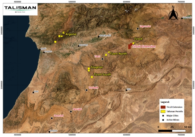
Figure 1: Project Location Map
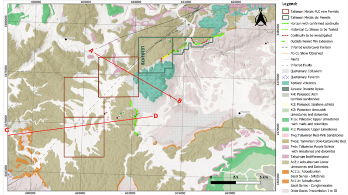
Figure 2: Geological Map of Tirzzit region showing Talisman Metals’ new permits and cross section positions

Figure 3: Conceptual geological cross section on A-B transect (See Figure 2)

Figure 4: Conceptual geological cross section on C-D transect (See Figure 2)
Important Disclaimer: The geological targets and exploration concepts referred to in this announcement are based on publicly available information, including regional geological maps, government geological survey data, academic publications, and other open-source datasets. The Company has not yet undertaken sufficient exploration work to independently verify the accuracy, completeness, or relevance of these datasets within the licence areas.
The geological targets described in this announcement are conceptual in nature. There has been insufficient exploration to estimate a Mineral Resource, and it is uncertain whether further exploration will result in the estimation of a Mineral Resource. Accordingly, investors should not place undue reliance on the geological interpretations, exploration concepts, or potential mineralisation described herein until they have been validated through field mapping, geochemical sampling, geophysical surveys, trenching, drilling, and other exploration activities conducted by the Company.


 Abmec
Abmec